What Is the International Date Line?
The International Date Line (IDL) is an imaginary line on Earth’s surface defining the boundary between one day and the next.


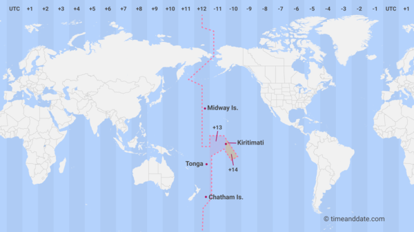
The International Date Line follows a path near the 180° longitude but deviates to accommodate national borders.
©timeanddate.com
Where Is the International Date Line?
The International Date Line (IDL) is located at about 180° east (or west). It is halfway around the world from the prime meridian (0° longitude), the reference point of time zones, which runs through Greenwich, UK.
The date line runs from the North Pole to the South Pole and marks the Western and Eastern Hemisphere divide.
It is not straight but curves around landmasses and national borders. For example, it leans towards the east at the Bering Strait between Asia and North America, leaving Cape Dezhnev in Siberia, Russia, a day ahead of Cape Prince of Wales in Alaska, USA, even though they are only 80 km (50 mi) apart.
See the date line on our Time Zone Map
The Northern and Southern Hemispheres
Different Days on Either Side
The International Date Line is also known as the “Line of Demarcation” because it separates two calendar dates. When you cross the date line traveling east, you subtract a day, and if you cross the line traveling west, you add a day.
For example, Kiribati and Hawaii are on different sides of the date line. If you traveled from Kiribati’s capital, Tarawa, to Hawaii’s state capital, Honolulu, you would have to turn the clock back 22 hours, effectively traveling back in time, at least on the calendar.
Not Always 24 Hours
Depending on the country’s time zone, the time difference on either side of the line is not always 24 hours. For example, if you travel the 1061 km (659 mi) across the date line from Baker Island to Tokelau, you must add 25 hours, or 1 day and 1 hour.
Three Dates at the Same Time
Every day between 10:00 and 10:59 UTC, three different calendar dates are in use simultaneously on Earth.
For example, May 2 at 10:30 UTC, is 23:30 (11:30 pm) on May 1 in American Samoa (UTC−11), 06:30 (6:30 am) on May 2 in New York (UTC-4), and 00:30 (12:30 am) on May 3 in Kiritimati (UTC+14).
See it for yourself in our Time Zone Converter.

Where December 30, 2011 never happened: In 2011, Samoa skipped a calendar day by moving the International Date Line.
©iStockphoto.com/Mark Fitzsimons
Changes in the Date Line
The International Date Line is not defined by international law, and it is up to the different countries to choose the date and time zone they want to observe.
In 1994, the Republic of Kiribati aligned the country’s time zones by skipping January 1, 1995 in the country’s portion east of the date line. By adding 24 hours to the clocks in the Phoenix and Line Islands, they put a dent in the date line, moving it all the way to 150° east longitude.
In 2011, Samoa changed its time zone from UTC-11 to UTC+13 by shifting the date line to the west and removing December 30, 2011 from the calendar. They did this to facilitate trade with Australia and New Zealand, and Tokelau followed Samoa for the same reasons.
The Nautical Date Line
The International Date Line should not be confused with the Nautical Date Line, which follows the 180° meridian from the North to the South Pole. Unlike the International Date Line, whose course is determined by the countries bordering it, the Nautical Date Line is defined by international agreements.
Drawn up in 1884
The 180° meridian was selected as the basis for the International Date Line because it mostly runs through the sparsely populated Central Pacific Ocean. This decision was made at the International Meridian Conference held in Washington, DC, in 1884.