How Are Time Zones Decided?
And what makes a country change its time zone? Is it based on geography, politics, relationships—or all of the above?

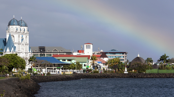
Apia, capital of Samoa: In 2011, the Pacific island nation switched time zones in one of the most radical time zone changes in recent history to align with trading partners Australia and New Zealand.
©iStockphoto.com/virsuziglis
Have you ever wondered why time zones have such irregular shapes and why no international time zone authority smooths out the dents and bulges in the time zone map?
The answer is simple: no such global regulatory body exists. Each country determines its own time zone and decides whether or not to observe Daylight Saving Time (DST).
“There is nobody that can say yes or no. The country decides for itself. Then it’s just a matter of publicizing it, informing the international community and the map-makers.”
David Mumford, of mapmaker Collins Bartholomew, to the BBC when Samoa changed time zones in 2011
In reality, of course, countries aren’t completely free to decide which time zone to use. A number of factors restrict and influence their choice, the primary one being geographic location.
The Ideal Offset
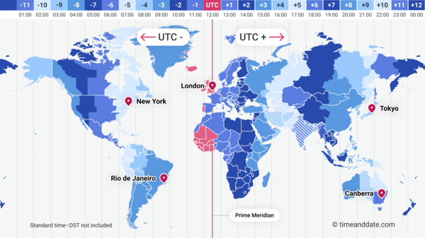
Picture the Earth as a giant clock. Our planet rotates 360° in 24 hours, which means it rotates 15° per hour. Dividing the globe into 15° sections creates 24 ideal time zones, each with a one-hour difference.


The UTC offset is the difference in hours and minutes between UTC (vertical red line) and the time at a particular place. Note that Daylight Saving Time is not included in this illustration. See the current status in our time zone map.
©timeanddate.com
Now, imagine being responsible for choosing a time zone for your country. All other factors aside, it would make sense for you to choose the 15-degree slice where the clock shows about 12 noon as the Sun reaches its highest point in the sky.
That’s why, despite all the oddly shaped time zones out there, most countries stick roughly to the ideal offsets for their longitudes—but there are exceptions.
Economy, Politics, and Traditions
Geographic location is the primary factor, but a combination of economic ties, political alliances, and historical traditions can also play a significant role in choosing a time zone.
In some cases, time zone decisions can be purely political. Imagine living in western China, where the Sun might rise at 10 am because of Beijing’s single time zone policy. Or in India where the Sun could rise at 06:14 (6:14 am) over Kolkata in the east and at 07:27 (7:27 am) over Jamnagar in the west on Christmas Day due to India’s single time zone. These are examples of how governments use time to foster unity—though it often leads to quirky daily routines for people far from the capital.
Which country has the most time zones?
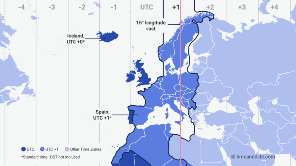
Spain chose to align with Central European Time to strengthen ties with its neighbors, even if it means their dinner starts at 21:00 (9 pm). Spain’s unusual time zone means that Spaniards often get up before daybreak and go to bed at sunset.
It all dates back to the Second World War when Spanish Fascist dictator Francisco Franco changed Spain’s time zone to be in the same time zone as Germany and to save energy for the war effort. After the war, other countries returned to their old time zones, but Spain stayed on UTC+1.


Central European Time (CET) is based on mean solar time at longitude 15° East, however, western parts of Spain are almost 2000 kilometers (1200 miles) away. This results in civil time being almost two hours ahead of true local time for some places in Spain. For Iceland, the noon offset is also about 1 to 1.5 hours.
©timeanddate.com
Iceland has been in Greenwich Mean Time (UTC+0) since 1968. Iceland’s position on the map above shows how weird that placement is. While London and Reykjavík may share the same noon time (when the UK is on standard time), the Sun reaches its highest point in Iceland around 13:00 (1:00 pm) GMT. In the most westerly parts of the country, this peak occurs even later in the day. Despite much debate, Iceland decided in 2020 to remain in its time zone.
Time zones, in this sense, are not just about clocks—they’re about relationships, habits, and shared rhythms.
The Boundary Between Days
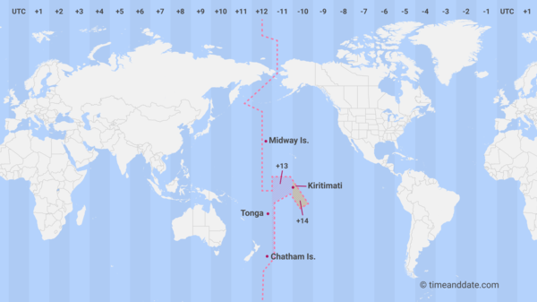
As each country selects its local time, time zone boundaries can become distorted. This also affects the International Date Line (IDL), the boundary between calendar dates that zigzags through the Pacific Ocean. Essentially, the IDL is just another type of time zone boundary.
For example, the Republic of Kiribati moved the IDL in 1994 to align its time zones, and Samoa shifted it west in 2011 to ease trade with Australia and New Zealand, skipping December 30 that year.


Kiribati’s time zone adjustment resulted in the characteristic bulge in the IDL close to the equator.
©timeanddate.com
By moving the dateline, Kiribati became the first country to enter the third millennium and has ever since been the first country to enter the New Year.
What Makes Some Countries Change Time Zones?
Time zone shifts often reflect changes in a country’s priorities. Samoa’s decision in 2011 to align with Australia and New Zealand wasn’t just practical—it symbolized a closer cultural and economic connection with neighbors. These decisions remind us that time is as much about human relationships as it is about seconds and minutes.
In the 2022 autumn session, the government of Greenland, Naalakkersuisut, passed a law that allows the country’s standard time to change from UTC−3 to UTC−2. The decision was made to close the time zone gap with Europe. (Even though the time zone change does not include the areas of Ittoqqortoormiit, Danmarkshavn, and the Thule Air Base.)
Some countries adopt offsets smaller than an hour to align their clocks with the solar day better. For instance, India (UTC+5:30) finds this offset more practical for its longitude. Nepal (UTC+5:45) is even more specific due to its unique location.
In 2015, North Korea abandoned the time zone it shared with Japan and South Korea (UTC+9) and created its own, Pyongyang Time, UTC+8:30. The decision was made to spite the “Wicked Japanese Imperialists,” said KCNA, North Korea’s state mouthpiece. The decision was reversed in 2018 as a step in “unifying Korea and eliminating differences between the South and North.”
The Never-Ending DST Debate
Another time-related decision every country needs to make—and one that can lead to even more distortion of time zone boundaries—is if they should use Daylight Saving Time (DST) or not.
Regions with DST adjust their time and time zone names, adding terms like “daylight” or “summer,” twice a year. For example, California observes Pacific Daylight Time (PDT) during DST and switches to Pacific Standard Time (PST) for the rest of the year.
Areas without DST stay on standard time year-round.
In recent years, there’s been much debate about whether to keep or skip the seasonal clock changes twice a year.
In 2019, the European Parliament supported a proposal from the European Commission to eliminate DST in EU member countries. However, in 2021, the proposal stalled in the European Council because of practical concerns about implementing such a change.
In the US, 19 states want to “lock the clock” and keep summertime year-round.
Hate clock changes? This expert disagrees
Countries near the equator seldom use DST due to the consistent nature of daylight in these regions. The equator experiences nearly equal amounts of daylight and darkness throughout the year, with days and nights lasting roughly 12 hours each, regardless of the season.
